Northern Ionian Loop: Corfu, the Diapontia Islands & a Taste of Albania in 7 Days
Updated
The Diapontia Islands sit within a day's sail of Corfu Town, yet most charter boats never find them. This seven-day loop maps a practical northern Ionian circuit through near-deserted Erikoussa, Mathraki, and Othoni — with an optional overnight across the Albanian border into Saranda for sailors who want the full story.
On this page

Most Ionian itineraries start in Corfu, glance at Paxos, and head south. The northern Ionian tells a different story — one that most charter fleets never bother to print on their route cards. Within a day's sail of Corfu Town you have three near-deserted islands, an Albanian coastline that looked like the Amalfi of 1960 right up until recently, and anchorages where, in July, you might share the bay with fewer than a handful of other boats. This loop does all of it in seven days and brings you home.
Why Sailors Choose This Route
The northern Ionian extension is picked for three reasons: first-timers who based themselves in Corfu and want to avoid the downwind slog south before they have their sea legs; experienced sailors who have already done the Paxos–Lefkada circuit and want something genuinely fresh; and anyone running a one-way delivery from Corfu toward Brindisi who wants a few quiet days before the channel crossing.
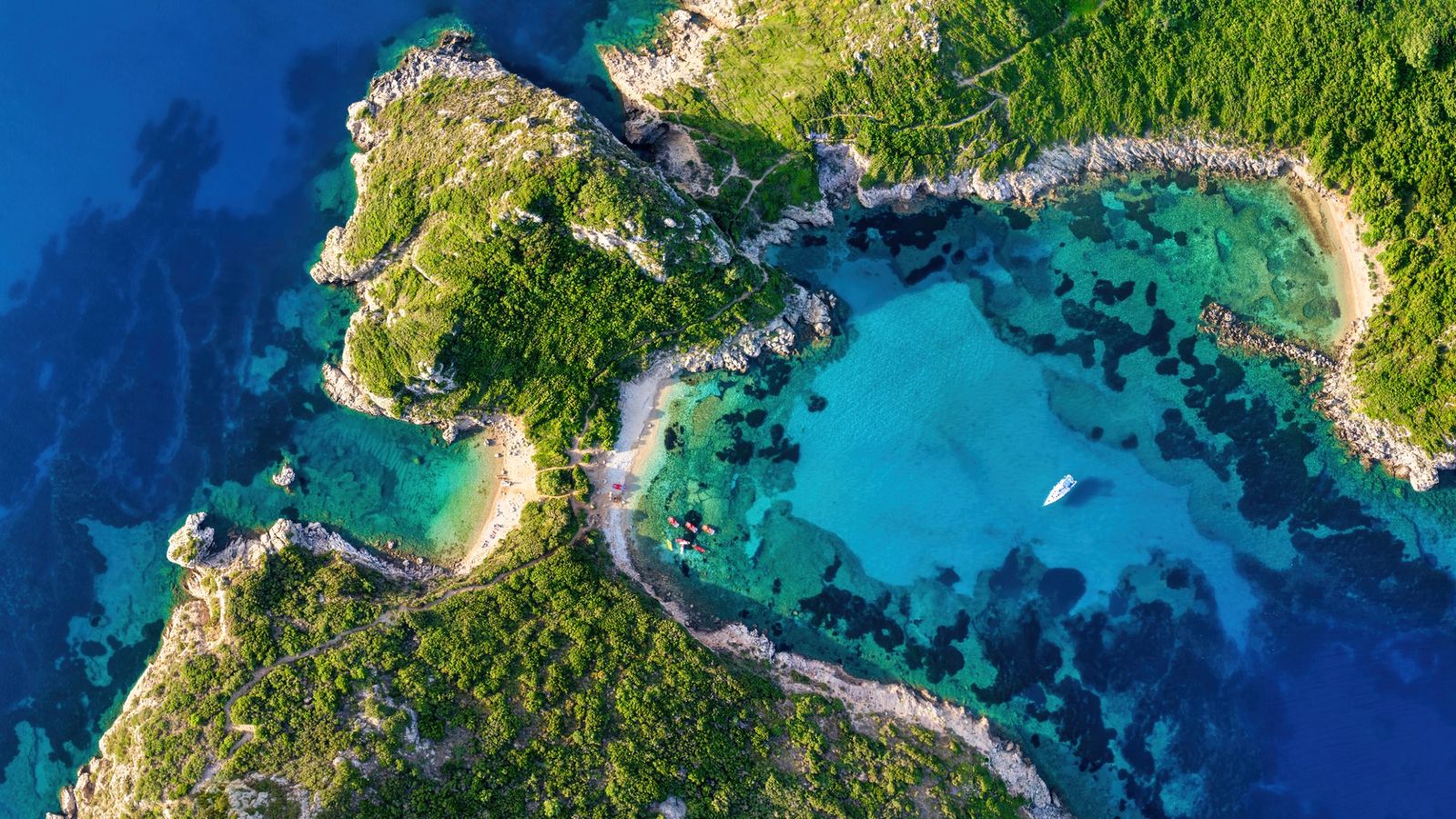
The Diapontia Islands — Erikoussa, Mathraki, and Othoni — sit 10 to 20 nautical miles northwest of Corfu and are administratively part of the Corfu municipality, yet in character they are closer to the outer Cyclades of forty years ago. Fishing families, a single kafeneion on each island, and no charter traffic to speak of. Albania's Riviera coast, visible from northern Corfu on any clear morning, adds a border-crossing dimension that most sailors assume is bureaucratically impossible. It is not — but it does require preparation.
Logistics and Paperwork
Greek Departure and Return
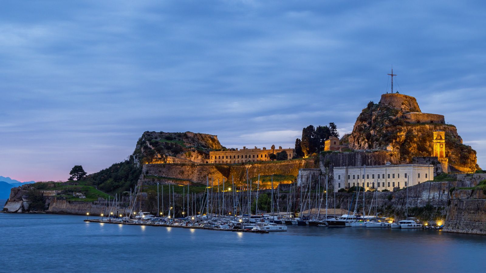
Your base port is Corfu Town. The main marina (Corfu Marina) can berth up to around 200 boats and is the logical place to start and end your loop. Corfu Town is also the port of entry and exit for Schengen purposes, and the regional port authority (Limenachio) is a five-minute walk from the marina. Before leaving for Albania — even on a day trip — you are required to check out of Greece formally. Carry your Transit Log (the Greek cruising permit) and present crew lists in triplicate as the port authority here still operates on paper. Allow 90 minutes on a busy morning in July.
Albania: Day-Trip Reality
The Albanian Riviera is theoretically open to visiting yachts, and the two most practical stops are Saranda (the main port) and Himara (an anchorage with a small harbor). Saranda has a small marina and a functioning customs and border office. However, day-tripping by private or charter yacht to Albania involves two formal border crossings — Greek exit and Greek re-entry — each requiring port authority sign-off. For a one-day excursion, the paperwork overhead is genuine.
The practical reality for most sailors doing this loop in seven days is to treat Albania as an optional overnight rather than a rushed day trip. If you do cross, the sequence is: check out at Corfu Limenachio in the morning, sail 15–18 nautical miles to Saranda, clear Albanian customs and immigration on arrival (they operate 24 hours but mornings are smoother), and check back into Greece at Corfu Town or the Corfu Customs Anchorage on return. Bring original passports, not photocopies. As of 2024, EU and US citizens do not need a visa for Albania for stays under 90 days.
Charter-Company Rules
This is the single most important planning point. Many Greek charter operators have clauses prohibiting passage into Albanian waters or require written pre-authorization. Some companies with bases in Corfu do permit Albania crossings — but only if you book the option at the time of chartering and pay an additional insurance premium. Check your charter contract for the words "territorial limit," "Albania," and "cross-border." If Albania is prohibited and you go anyway, your insurance is void. If you are on a bareboat and the contract is clear, call the operator before departure day.
For the Diapontia Islands, no special permission is needed — they are Greek sovereign territory and your Greek Transit Log covers them fully.
One-Way Drop-Offs
This is a loop itinerary returning to Corfu, so one-way fees do not apply to the main trip. If you are considering extending it — say, finishing in Brindisi or Katakolon — most operators charge a relocation fee of €300–€800 depending on the base involved. Corfu-to-Italy one-way is among the more commonly requested options from Ionian fleets, and some operators run it regularly as a delivery route with shared cost.
Weather and Difficulty
Wind and Sea State
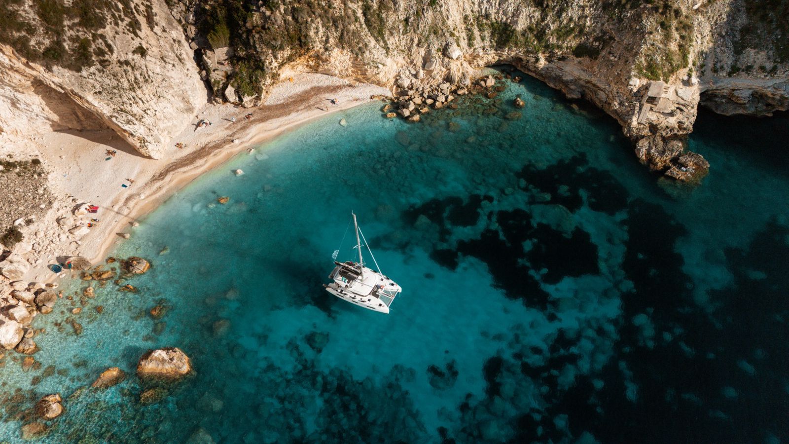
The northern Ionian in summer is dominated by the Maestro — the local name for the northwesterly that builds each afternoon from late June through August. It is generally a force 3–4 sea breeze, occasionally reaching force 5 on the nose when you are sailing back toward Corfu from the northwest. This means morning departures for the northwesterly legs, before the Maestro has built, and afternoon arrivals when the wind can help you home. The Diapontia Islands offer limited shelter from the northwest; Erikoussa's small harbor faces east and gives better protection than the open roadstead on the west side.
The Corfu Channel — the narrow strait between Corfu and mainland Greece — can produce accelerated winds and a short, steep chop when the Maestro funnels through. If you are coming back down the east coast of Corfu in the afternoon, expect 15–20 knots apparent and a lumpy meter-high sea. It is manageable and often exhilarating, but not a passage for anyone who gets seasick on inland lakes.
Best Months
May and early June offer the most settled conditions, with lighter winds, better underwater visibility, and dramatically fewer boats. The flip side is that some small-island facilities (fuel on the Diapontia Islands, for instance) may not have resumed seasonal hours. Late June through July is peak season — the weather is reliable but the afternoons are breezy and anchorages at Paxos (if you dip south) fill early. September is arguably the best month: the Maestro softens, the sea temperature stays above 24°C, and Corfu Town empties of package tourists.
Difficulty Rating
Intermediate. This loop is not a blue-water crossing, but it is not a beginner's sheltered-bay tour either. The open-water passages to the Diapontia Islands (10–20 nautical miles each way across open Ionian water) expose you to the full force of any building northwest swell. You should be comfortable at the helm in force 4–5 conditions, confident in piloting a marina berth stern-to, and capable of anchoring independently. The Albania leg adds border-crossing logistics and slightly less predictable port infrastructure. Minimum recommended experience: at least one previous week-long charter in the Ionian or similar, with offshore passages.
Day-by-Day Passage Plan
Day 1: Corfu Town to Kassiopi (18 nm)
Clear marina early — there is often a queue at the fuel dock on Mondays when charters turn over. Leave Corfu Town north-bound through the narrows and sail up the east coast of Corfu, which is sheltered, green, and genuinely beautiful. The Maestro barely reaches this coast before noon. Kassiopi is a compact village harbor on the northeast tip; there are laid berths with water and a small taverna row. This is your staging post for the Diapontia crossing. Distance: 18 nm. Estimated sailing time: 3–4 hours under sail and motor-sail.
Day 2: Kassiopi to Erikoussa (20 nm)
Depart Kassiopi by 0700 at the latest. The crossing to Erikoussa is open water — you will likely motor the first hour in the calm, then get the Maestro on the beam as it builds. Erikoussa is the most visited of the three Diapontiots, which means perhaps a dozen boats in high season. The harbor is small; if it is full, the east-coast anchorage in 4–6 meters on sand is comfortable in the Maestro. Spend the afternoon walking the island — you can cross it in twenty minutes. Population is under 200. No fuel dock; carry enough for the loop. Distance: 20 nm. Estimated time: 4–5 hours.
Day 3: Erikoussa to Mathraki (8 nm) — Optional Albania Day
Mathraki is the least-developed of the three Diapontiots — forested, quiet, and with a single beach taverna that operates on its own schedule. The sail between Erikoussa and Mathraki is short, which gives you the afternoon to either rest properly or, if your charter permits it and you checked out of Greece at Kassiopi or arranged it by phone with Corfu port authority, make an afternoon run to Saranda (Albania) — roughly 22 nm from Mathraki — with an overnight there. If you do the Albania overnight, your Day 4 becomes the return leg. If not, Day 3 is a rest day, which this loop earns.
Day 4: Mathraki to Othoni (12 nm) — or Return from Saranda
Othoni is the largest and westernmost of the Diapontia Islands and historically notable as the mythological Ogygia — the island where Odysseus was held by Calypso. The harbor at Ammos Bay on the southeast coast takes a dozen boats. The village uphill is sleepy in the best sense. Sail here from Mathraki for an overnight if you skipped Albania, or return here from Saranda before continuing south. Distance Mathraki–Othoni: 12 nm.
Day 5: Othoni to Agios Stefanos NW, Corfu (22 nm)
This is the day the Maestro works in your favor. Leave Othoni in the morning, point the bow southeast, and let the building northwesterly push you toward the northwest corner of Corfu. Agios Stefanos (not to be confused with the village of the same name on the east coast) is a small resort village with a protected bay and anchor-and-stern-to along the quay. Good provisioning for a northwest Corfu stop. You are now back in the Ionian proper, with the familiar scent of pine coming off the Corfu hills. Distance: 22 nm.
Day 6: Agios Stefanos NW to Paleokastritsa to Gouvia (30 nm)
Paleokastritsa on Corfu's west coast is one of the iconic anchorages of the whole Ionian — a series of coves beneath a Byzantine monastery perched on a headland. Arrive before 1100 to get a spot in the inner cove before the day-trip boats arrive. Lunch here, swim, then continue south and around the cape into Gouvia Marina — the largest marina on Corfu and only 8 nm north of Corfu Town. Gouvia has fuel, a chandlery, showers with real water pressure, and several restaurants. Distance: 30 nm, including the Paleokastritsa detour. This is your longest day but the wind is typically behind you.
Day 7: Gouvia to Corfu Town (8 nm)
A gentle, stress-free final morning. Motor or sail south to Corfu Town marina for your handover. The Corfu Channel in the morning is almost always flat. Leave Gouvia by 0900 to avoid the lunchtime charter scramble at the fuel dock in Corfu Town. You have time for a final coffee in the Liston arcade and a walk around the Old Fortress before the flight home. Distance: 8 nm.
Total Distance and Realistic Timeline
The full loop without the Albania overnight runs approximately 118 nautical miles over 7 days. With the Albania extension, add roughly 44 nautical miles and accept that Day 3 becomes more logistically demanding. Average daily distances are 15–30 nm — well within a half-day of sailing — which is deliberate. The point of this loop is not passage-making but the character of the stops.
Backup Stops and Contingency Planning
If the Maestro Buries the Diapontia Crossing
A northwest force 5–6 makes the Diapontia crossing uncomfortable for less-experienced crews. The backup is to abort after Day 1 and turn the loop into a Corfu east-coast circuit: Kassiopi north to the bay at Agios Spiridon, down to Kouloura (a tiny horseshoe harbor that appears on every Corfu postcard), then Kalami and south. All of these are sheltered from the northwest. It is not the loop you planned, but it is not a wasted week either.
If Erikoussa Harbor is Full
The east-coast anchor in 4–5 meters on sand is comfortable in light to moderate northwesterlies. Holding is good. Set your anchor watch if winds are forecast above 15 knots overnight.
If Albania Clearance Hits Delays
Saranda customs can take 2–3 hours on a busy summer morning. If you are on a tight 7-day schedule, do not attempt Albania as a day trip — the margin is too thin. Treat it as an overnight or skip it this time. The Greek islands on this loop are the draw; Albania is the bonus.
Practical Notes
Fuel is available at Corfu Town, Gouvia, and Kassiopi. The Diapontia Islands have no fuel dock — carry full tanks from Kassiopi. Water is available at most harbor quays but quality varies; carry 60+ liters in containers if you have more than two aboard. VHF Channel 12 is used by Corfu Port Authority. Greek mobile coverage (Cosmote and Vodafone) extends to the Diapontia Islands but can be patchy on Mathraki. Albanian mobile coverage in Saranda is functional on roaming.
The Pilot Book to carry is Rod Heikell's Ionian Islands Pilot (current edition) — it covers the Diapontiots in detail and includes an Albania section with diagrams for Saranda. Cross-reference with the Greek Water Taxi app and Navily for current depth and berth reports from other sailors, which in the northern Ionian are more reliable than the paper pilot for anything updated in the last two years.
Frequently asked questions
Do I need a visa to sail to Albania from Greece?
As of 2024, EU and US passport holders do not need a visa to enter Albania for stays under 90 days. However, you must formally check out of Greece before crossing, clear Albanian customs and immigration on arrival in Saranda or Himara, and check back into Greece on return. Each border crossing requires original passports, crew lists, and your Greek Transit Log. Allow 2–3 hours for the Albanian clearance process in summer.
Can I take a Greek charter boat to Albania?
Many Greek bareboat charter companies prohibit crossing into Albanian territorial waters, or require written pre-authorization and an additional insurance premium arranged at the time of booking. If you cross into Albania without authorization, your charter insurance is void. Check your contract for the words 'territorial limit' and 'Albania' before departure, and call your operator if you are unsure.
How far are the Diapontia Islands from Corfu?
The Diapontia Islands — Erikoussa, Mathraki, and Othoni — lie 10 to 20 nautical miles northwest of Corfu Town. From Kassiopi on the northeast tip of Corfu, the crossing to Erikoussa is approximately 20 nautical miles of open water, typically taking 4 to 5 hours depending on the wind.
Is fuel available on the Diapontia Islands?
Fuel is not available on the Diapontia Islands. Fill your tanks completely at Kassiopi before making the crossing, and plan your fuel consumption for the entire Diapontiots leg before refueling again at Gouvia or Corfu Town on the return. Fuel docks are operational in Kassiopi, Gouvia Marina, and Corfu Town Marina.
What is the best time of year to sail the northern Ionian and Diapontia Islands?
September is the best month for this loop. Winds are lighter and more stable than July and August, the Maestro northwesterly is less aggressive in the afternoons, the sea temperature remains above 24 degrees Celsius, and the anchorages are noticeably less crowded. May and early June are also excellent for settled conditions but some small-island facilities may not be fully open for the season.
How difficult is the sailing loop around Corfu and the Diapontia Islands?
This is an intermediate-level itinerary. The open-water crossings to the Diapontia Islands are 10 to 20 nautical miles of exposed Ionian water, and the afternoon Maestro northwesterly regularly reaches force 4 to 5. You should be comfortable helming in those conditions, confident berthing stern-to in a tight Greek harbor, and able to anchor independently. At least one previous week-long Ionian charter with offshore passages is the recommended minimum.


